The recent post about Buckley Street – a walking tour thereof and commentary upon – drew many comments.
It also unloosened much curiosity and speculation about the Footscray, Middle Footscray, West Footscray, Tottenham, Seddon and Yarraville – and the seemingly flexible borders that separate them.
So this a follow-up post.
I am specially indebted to the sleuthing of CTS pal Juz.
I figure there’s folks around who may have a much more soli handle on this than I – perhaps at the Footscray Historical Society.
But I get a kick out of looking at this stuff anyway.
I hope you do, too!
****
Wow!
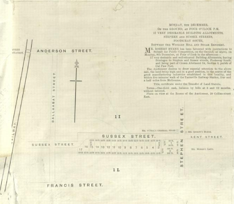
The above map from 1870 – trackled down at the State Library – is of what is now Yarraville.
It talks of “very desirable” allotments in Stephen and Sussex streets – in Footscray South!
According to the wikipedia entry on Seddon, “The Original State Bank of Victoria in Charles Street, Seddon used to stamp its Bank Account passbooks as Footscray South Vic”.
However, wikipedia also maintains that “Seddon Post Office opened on 29 September 1908 and closed in 1976. Seddon West Post Office opened in 1924 and remains open”.

The State Bank’s annual report from 1982 lists a Footscray South branch.
Hamilton Street is, of course, part of modern day Seddon.
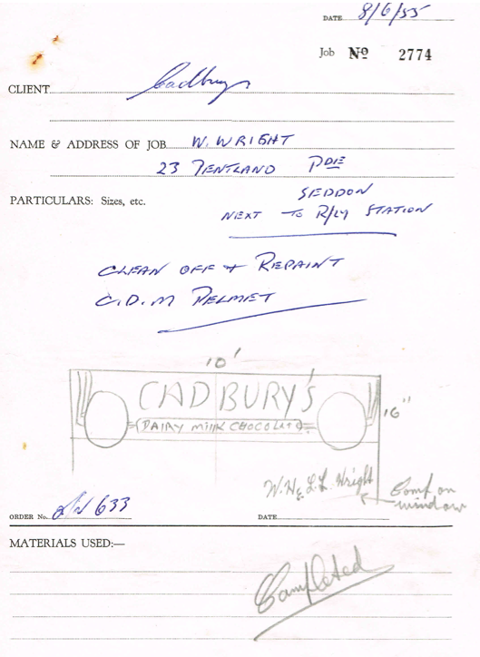
On the other hand, in 1955 a Cadbury’s milk bar had struck a deal (above) with signwriting company Lewis & Skinner to “clean off and repaint” the shop’s pelmet. Thanks to Melissa for this one!
This family history site twice lists Pilgrim Street as being in Footscray South.
A final question: Will the headline of this post find the electronic gaze of the spooks focusing on Consider The Sauce?
I kinda hope so.
After all, spies gotta eat as well!

I was a teller in the Charles St Footscray South SSB whilst the old bank building near Seddon Station was Seddon SSB!
Imagine that today – having two branches of the same bank within easy walking distance of each other. Instead the area has none.
LikeLike
I’ll happily join the Greater Footscray Liberation Front, particularly since I was a member of the Mount Duneed Anti-progress Committee.
LikeLike
Got shit-stirrer form, eh?
LikeLike
I wonder if Seddon originally referred to the area around the train station? Both of the premises from Pablo’s comment and the signwriting quote are within a good drop punt of the station. But someone else said in your other post that the station was named after the suburb, not vice versa. Could be that over time Seddon crept westwards, either officially or unofficially?
On another tangent, how is it that both Seddon and Footscray inherited postcode 3011?
LikeLike
Another angle – one that I’ve been subliminally aware of for a long time but which didn’t fully register until I was looking at online maps at work the other day.
That is … that Kingsville and South Kingsville are not connected.
A colleague reckons the timeline goes something like this …
First there was Yarraville until Williamstown Road, with Kingsville entire west of there.
Then sometime Kinsgville entire disappeared entirely, leaving only Kingsville South and Greater Yarraville. (As with other local boundaries and perceptions discussed on this post and the earlier one, Yarraville is actually a lot bigger than many people realise.)
Then, some time – in the ’80s or ’90s? – a residents’ push saw Kingsville re-instated as a suburb with the current triangular boundaries of Somerville Road, Williamstown Road and Geelong Road.
LikeLike
Kingsville existed as district at least back to the late 50s. Generally speaking it was all that area north of Somerville Rd and east of Robert St. Then somewhere in the vicinity of Mt Mistake overpass and Williamstown Rd, West Footscray or Seddon kicked in.
Sth Kingsville is an aberration but so are parts of Spotswood.
I’d say the area now known as Yarraville West is the fly in the ointment because it was, until immediately after the war, farmland, and I recall being a toddler in the new housing estate standing on the side fence coming face to face with cows. Angliss Reserve was a rudimentary paddock back then.
LikeLike
Thanks Pablo! It’s cool to have someone with first-hand memories contributing!
LikeLike
Others are a testament to people power, like the one-man push to put South Kingsville on the map (it comes under the Spotswood postcode). “One guy lobbied Australia Post so hard, the poor girl crippled under the paperwork and pestering. When she did, I had to.”
LikeLike
Our former neighbour moved into Stooke Street Yarraville when he was 30 years old and moved into 2nd house built in the Street. I think he said that there were no houses between Stooke Street and the Cemetery although the streets were probably marked out. He left when he was 92 years old! Still living in the area. Most of the Streets seem to have a butcher/ bovine reference in this patch.
LikeLike
Yes I would love to liberate Footscray from greedy developers and yuppies.
LikeLike